Digital Coast GeoZone

Tech talk for the Digital Coast

Menu Skip to content
  • Home
  • About
  • Digital Coast
    • Data
    • Tools
    • Training
    • Stories
    • Topics
  • Contact Info

Tag: DAV

December 9, 2021December 9, 2021Kirk Waters

DAV: New Products

October 22, 2021October 22, 2021Kirk Waters

Data Access Viewer: Changes

September 29, 2021September 29, 2021Kirk Waters

New Ways to Access Lidar
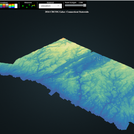
June 10, 2021June 10, 2021Kirk Waters

Lidar in XYZ

September 10, 2020December 7, 2020Kirk Waters

Download from a List of Files from Windows
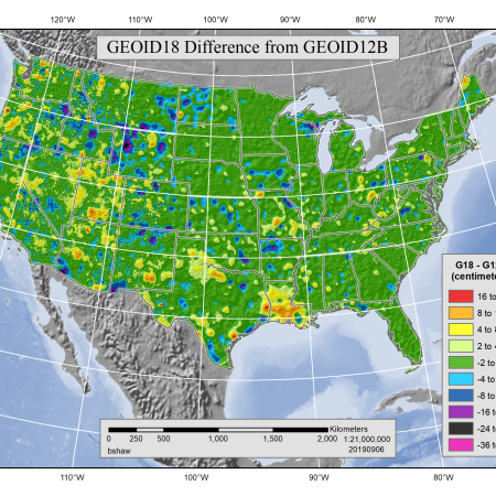
November 19, 2019December 10, 2019Kirk Waters

DAV Tips: GEOID18

October 25, 2019October 25, 2019Kirk Waters

The Choices People Make – Looking at the Stats

July 17, 2019July 17, 2019Kirk Waters

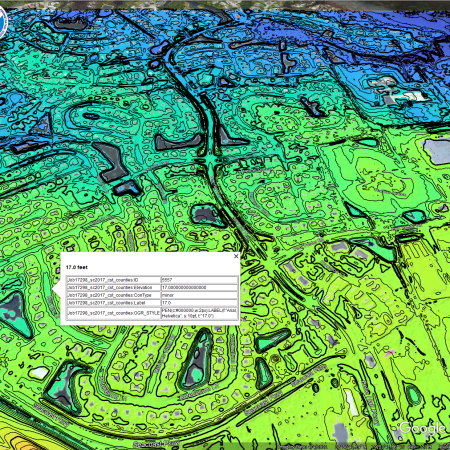
DAV Tips: Breaklines and Where to Find Them

May 1, 2019December 30, 2022Kirk Waters

Bulk Lidar Download on Digital Coast

April 17, 2018April 17, 2018Kirk Waters

Which metadata?

February 13, 2018July 19, 2021Rebecca Mataosky

Got Lidar?

September 13, 2017September 13, 2017Kirk Waters

DAV Tips: Size Estimates

August 24, 2017August 24, 2017Maryellen Sault

Show Me the Data!

May 29, 2017February 22, 2022Kirk Waters

DAV Tips: DEMs or Points

January 30, 2017May 4, 2020Kirk Waters

Lidar and ArcGIS

Posts navigation

1 2 →

Categories

  • Economics
  • Elevation
  • General
  • Imagery
  • Land Cover
  • Marine Cadastre
  • Sea Level Rise
  • Water Quality

Enter your email address to subscribe to this blog and receive notifications of new posts by email.

Join 77 other subscribers

RSS Feed RSS - Posts

Tags

accuracy ArcGIS bathymetry change climate change coastal and marine spatial planning Coastal Change Analysis Program (C-CAP) coastal economy coastal flooding coastal geotools coastal mapping contours data data access datum DAV DEM download economy elevation ellipsoid enow Esri flood GDP geeks geoid georeference GIS Green Infrastructure habitat hurricane Hurricane Sandy Imagery indicator inundation jobs land cover land cover data Landsat Landsat Data Continuity Mission land use LAS LAZ lidar map comparison mapping map services metadata minimum mapping unit National Climate Assessment ocean uses organization orthometric pdal planning poetry Python QGIS raster remote sensing requirements resolution return on investment Sea Level Rise spatial standard statistics tides TIFF tools topography USGS usiei water quality
  • Follow Following
    • Digital Coast GeoZone
    • Join 77 other followers
    • Already have a WordPress.com account? Log in now.
    • Digital Coast GeoZone
    • Customize
    • Follow Following
    • Sign up
    • Log in
    • Report this content
    • View site in Reader
    • Manage subscriptions
    • Collapse this bar
 

Loading Comments...