Digital Coast GeoZone

Tech talk for the Digital Coast

Menu Skip to content
  • Home
  • About
  • Digital Coast
    • Data
    • Tools
    • Training
    • Stories
    • Topics
  • Contact Info

Tag: GDP

August 24, 2015August 24, 2015Jeff Adkins

The Gulf Coast Economy: Ten Years After Hurricanes Katrina and Rita

Banner image: Fishing with money for bait.
June 8, 2015August 4, 2015Tola Adeyemo

The Ocean Economy: It’s Still Big and Growing!

February 23, 2015August 1, 2015Jeff Adkins

The Ocean Economy: We Thought It Was Big—Turns Out, It’s Bigger

Fishing Pier near Wilmington, NC. Image from NOAA Photo Library
July 7, 2014November 23, 2015Gabe Sataloff

Speed Dating with the Coastal and Ocean Economies

March 24, 2014July 6, 2016Jennifer Zhuang

Why Should I Care about the Ocean and Great Lakes Economy? Ten Important Reasons

March 17, 2014July 6, 2016Jennifer Zhuang

What is the Ocean and Great Lakes Economy? Ten Utterly Fascinating Facts

April 10, 2013July 6, 2016Gabe Sataloff

Economic Indicators and the Hunt for the Big Number

Schematic showing gdp vs real gdp
February 19, 2013July 8, 2016Jennifer Zhuang

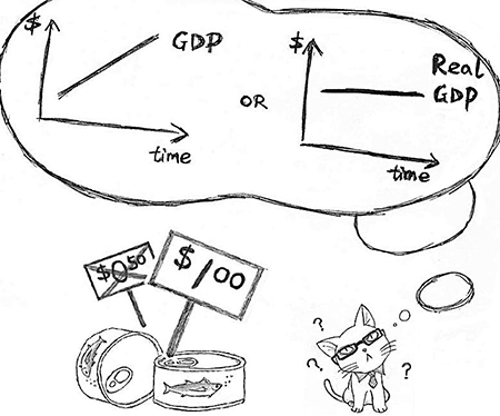
GDP, Real GDP, and Chained (2005) Dollars

Image of the day's catch being weighed.
October 9, 2012July 6, 2016Anonymous Staff

ENOW PLUS: Go Fish!

Categories

  • Economics
  • Elevation
  • General
  • Imagery
  • Land Cover
  • Marine Cadastre
  • Sea Level Rise
  • Water Quality

Enter your email address to subscribe to this blog and receive notifications of new posts by email.

Join 75 other subscribers

RSS Feed RSS - Posts

Tags

accuracy ArcGIS bathymetry change climate change coastal and marine spatial planning Coastal Change Analysis Program (C-CAP) coastal economy coastal flooding coastal geotools coastal mapping contours data data access datum DAV DEM download economy elevation ellipsoid enow Esri flood GDP geeks geoid georeference GIS Green Infrastructure habitat hurricane Hurricane Sandy Imagery indicator inundation jobs land cover land cover data Landsat Landsat Data Continuity Mission land use LAS LAZ lidar map comparison mapping map services metadata minimum mapping unit National Climate Assessment ocean uses organization orthometric pdal planning poetry Python QGIS raster remote sensing requirements resolution return on investment Sea Level Rise spatial standard statistics tides TIFF tools topography USGS usiei water quality
  • Follow Following
    • Digital Coast GeoZone
    • Join 75 other followers
    • Already have a WordPress.com account? Log in now.
    • Digital Coast GeoZone
    • Customize
    • Follow Following
    • Sign up
    • Log in
    • Report this content
    • View site in Reader
    • Manage subscriptions
    • Collapse this bar