
Have you ever found yourself in a situation where your boss asks you to do a GIS task and wants the results immediately? And when I say immediately, I really mean they wants the answer yesterday. So you drop everything you are doing to work on the request but then you realize that it is going to take FOREVER to get a result. Perhaps this is because it takes a long time for the GIS program to open and/or geoprocesses to complete or maybe it takes a looong time to refresh the view as you zoom and pan around. Whatever the case may be, extra seconds can feel like a lifetime when you have someone waiting on you. I recently found myself in a similar situation. Although I accomplished my task, I felt like there had to be another way. And that is when I fired up QGIS and took it for a test drive.
QGIS First Impressions
I’m not gonna lie – I was overwhelmed when I first opened QGIS. There are buttons everywhere and, unlike other GIS packages, it did not open with a view window. My first step was to do some googling to get my bearings but I had a hard time finding simple straightforward information. I found a few blog posts on the differences between GIS software packages and a good site for QGIS tutorials but I’m not a programmer and I don’t frequent github, so a fair amount of information was over my head. My next approach was to randomly click buttons and see what would happen. After fumbling around a little, I discovered a whole new GIS world and quickly became a QGIS fan.
Three Reasons Why
There is a laundry list of reasons why folks like QGIS. It is a free, open source GIS software package that has an active community. While I appreciate all of those things, I discovered a few more reasons to fangirl over QGIS.
Reason #1: Layout – I really like the new empty project layout. After opening it, my QGIS popped up with browser, layer and view windows. I could probably customize other GIS software packages to have a similar look but QGIS did it for me automatically. It was also nice to use the browser window to drag and drop files into the view or add various services.
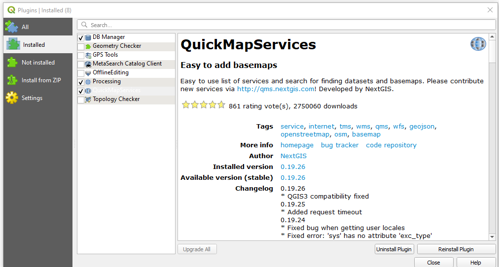
Reason #2: Plugins – Remember back in the day when ArcView 3.X had a repository of custom Avenue scripts that you could search. There were hundreds of custom scripts and it felt like you could always find a script to do the thing you needed. Well, welcome to that world again. I feel like QGIS has something similar. These custom tools are known as plugins. There are 734 custom plugins (according to version 3.14) that can be used free of charge without the need for admin privileges to install . (Talk about a win-win!) For example, you may wonder how to add a a basemap to your view. Just go to the Plugins window, click on All and then search for QMS (QuickMapServices). Then click on the Install Plugin button in the lower right hand corner. Your plugin window should look similar to the screenshot below.

Next, select Installed and check the QuickMap Services box. Your window should look something like this:
At this point, go to Web in the main toolbar, select QuickMap Services, and then select Search QMS. A new window will appear where you can search for basemaps. I searched for ESRI and got this list of services to add to my view:

Reason #3: Editing – There are two things that I really like about editing in QGIS. First, it is lightning fast. I think this is partly due to how quickly the view redraws after zooming and panning. Second, a pencil is displayed in the color box of the layer that you are editing. I find this editing indication super helpful when I have multiple layers displayed. It kind of reminds me of the good old ArcView 3.X days. To be fair, I should note that there is a learning curve when creating, splitting or reshaping a polyline. Namely, you need to right click the mouse to end the edit. This takes some time to get used to but it makes the editing process so much faster once you get the hang of it.
I could continue to provide more reasons why I became a QGIS fan but I’d rather you take the time to explore QGIS yourself. Give it a whirl! You may end up becoming a fan yourself. I hope this post provided a starting point for your QGIS adventure.

Yes, worked well for me too. QGis is one of the best GIS software I’ve used so far.
LikeLike