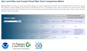
As a regional NOAA staff member who works with local communities and agencies on planning for sea-level change, the most frequent question I hear local planners ask is: what sea-level change tool or model should I use? As coastal communities have begun to grapple with the risks inherent in rising sea levels, government agencies and private organizations have responded with a growing array of sea-level rise and coastal flooding web tools and models. So the simple question these planners ask is understandable.
Two years ago in California, a group of professionals working on climate issues convened the primary sea-level rise tool developers to discuss the best way to portray the cornucopia of tools available for local decision makers. As part of that meeting, we pulled together a comparison matrix of all the current tools, so participants had a better understanding of each tool’s functionality. It occurred to us that this matrix could help communities sort through the plethora of available tools.
From this meeting three national organizations – NOAA, the Nature Conservancy and Climate Central – have come together to develop an online version of the sea-level rise tool comparison matrix that highlights key features and differences between these tools. Climate Central hosts this online resource and is working with NOAA to add additional state and regional tools for all coastal states. The searchable matrix contains six expandable menus:
- General information
- Sea-level rise and flood scenarios
- Exposure analysis
- Shoreline processes
- Technical specifications
- Other information
The matrix allows for side-by-side comparisons between tools where available for each coastal state, and allows you to print out or embed the matrix in your own website. If you do not see your favorite tool, then click on the links to download a blank tool template and submit for inclusion in the next version of the matrix.
So how do I answer the planner’s question about tools now? With the usual hedge: it depends. It depends on your planning questions, on the scale you are studying, on the system being analyzed – but finding the right tool for the right geography is certainly easier with the matrix.
A new landing page and new tools have just been added to the matrix, so click on over and see what is available in your state.

